 ar
ar bg
bg hr
hr cs
cs da
da nl
nl fi
fi fr
fr de
de el
el hi
hi it
it ko
ko no
no pl
pl pt
pt ro
ro ru
ru es
es sv
sv tl
tl iw
iw id
id lv
lv lt
lt sr
sr sk
sk sl
sl uk
uk vi
vi et
et hu
hu th
th tr
tr fa
fa ms
ms hy
hy ka
ka ur
ur bn
bn mn
mn ta
ta kk
kk uz
uz ku
ku
Digital Traversing Inclinometer
Kingmach Digital Traversing Inclinometer use different communication paths for different field needs. JMQJ-7315ADS uses RS485 digital output and works well in wired automated systems. JMQJ-7315RTU uses wireless 4G digital output and is better suited to sites where cables are difficult to run or where remote unattended measurement is expected. JMZX-7100L uses Bluetooth for mobile field reading and can store large amounts of inclinometer data for later analysis. JMQJ-7915ATS and JMZX-4QH support downhole multi-point data collection through grouped communication and acquisition modules. Communication planning should define cable route, antenna position, cabinet protection, baud rate, channel address, sampling interval, power mode, and fallback manual check method. The communication method is part of measurement quality because lost data, wrong channel names, or unstable power can confuse the tilt trend.

Application of Digital Traversing Inclinometer
Dam and embankment monitoring use Digital Traversing Inclinometer to follow angular change and internal deformation under water-level, seepage, consolidation, and seasonal effects. JMZX-7100L is used for horizontal displacement changes inside soil masses in dams and embankment slopes, while JMQJ-7915ATS can support fixed multi-depth monitoring in boreholes. Fixed tilt sensors may also be used on gallery structures, retaining walls, or equipment bases where angular change is important. Readings should be reviewed beside reservoir level, seepage, rainfall, pore pressure, settlement, and inspection notes. The work is long-term, so sensor orientation, borehole position, casing condition, and reference direction must be recorded carefully. A stable tilt or inclinometer record can help distinguish slow consolidation from localized deformation linked to water or structural change.
The future of Digital Traversing Inclinometer
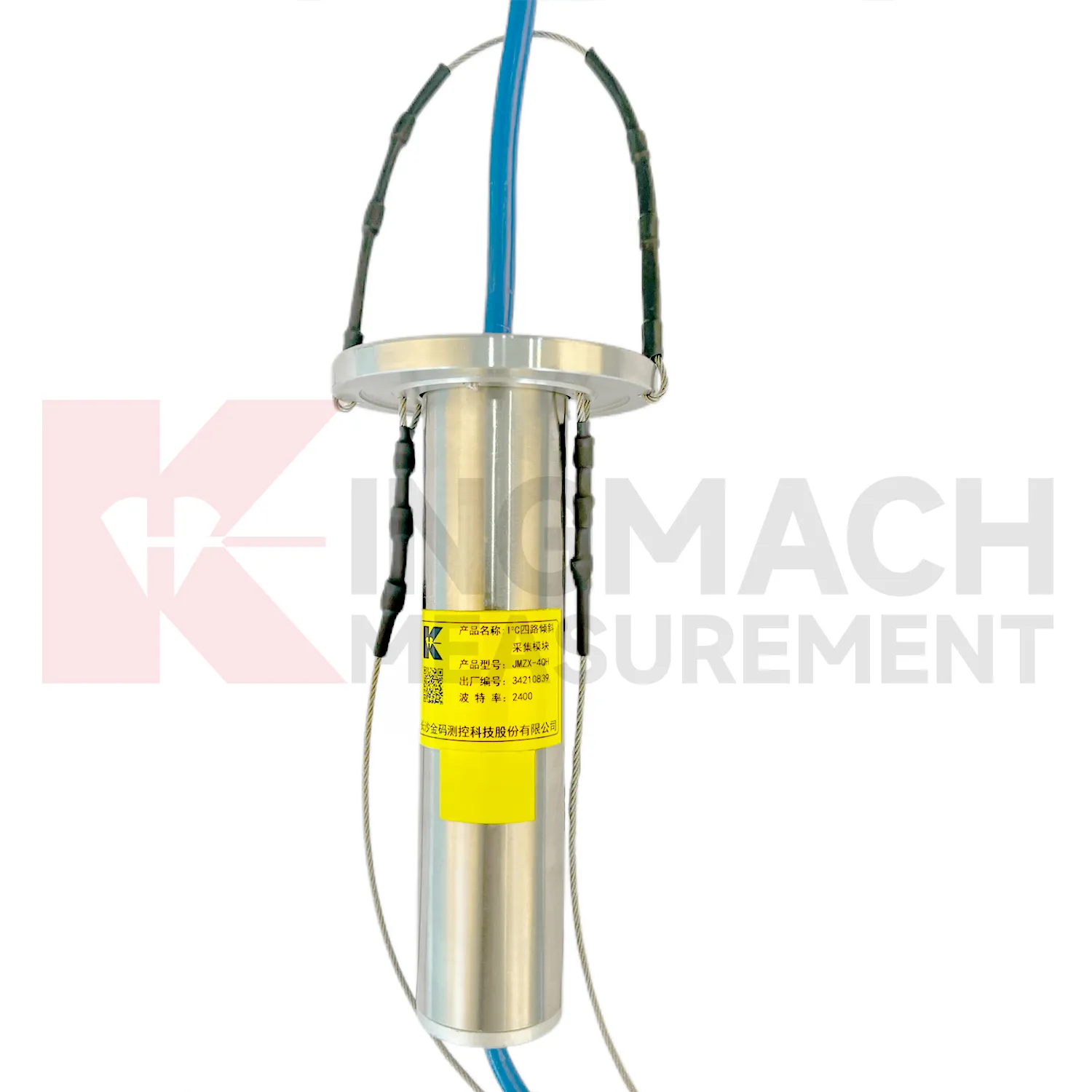
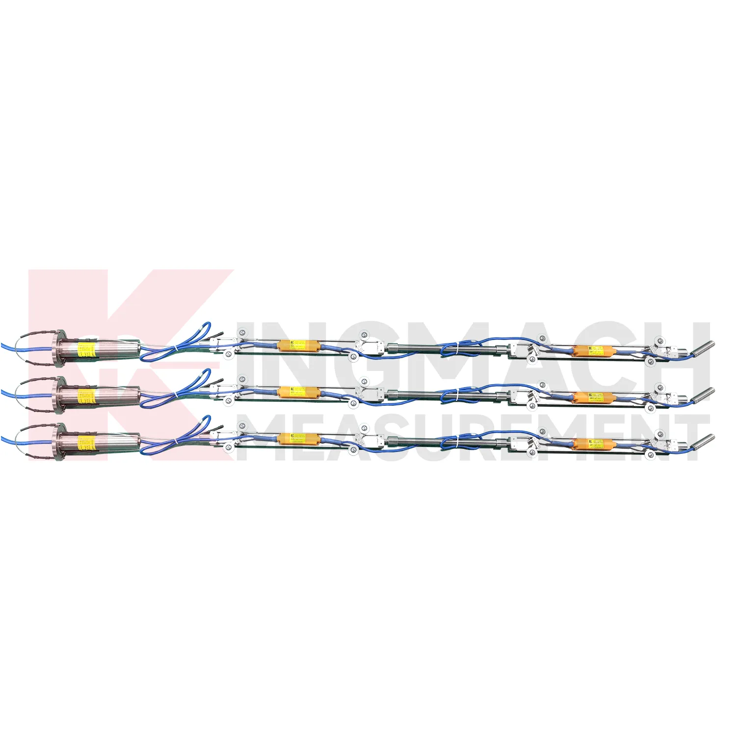
Multi-point borehole monitoring will continue to expand the role of Digital Traversing Inclinometer. JMQJ-7915ATS already connects multiple in-place inclinometer sensors through a single cable, with grouped communication, universal joints, connecting rods, electronic identifiers, and an orifice acquisition module. This type of system turns a borehole into a depth-based deformation profile rather than a single surface observation. Future improvements will likely focus on easier factory configuration, clearer point identification, lower power operation, and faster data review. Slopes, foundation pits, dams, embankments, and underground projects benefit from knowing where movement is happening inside the ground. Depth-specific tilt data can help teams move from general warnings to targeted inspection and reinforcement planning.
Care & Maintenance of Digital Traversing Inclinometer
Temperature and environment checks help maintain Digital Traversing Inclinometer accuracy. JMQJ-7315ADS operates from -30 degrees Celsius to +80 degrees Celsius, JMQJ-7315RTU from -10 degrees Celsius to +55 degrees Celsius, and JMQJ-7915ATS from -30 degrees Celsius to +70 degrees Celsius. Temperature drift, condensation, direct sunlight, ice, and cabinet heat can affect readings or communication hardware. Maintenance records should note weather, enclosure condition, ventilation, shading, and nearby heat sources. If a tilt curve moves with daily temperature, compare it with structural temperature and other sensors before treating it as deformation. Environmental review does not weaken the warning; it makes the warning more credible by filtering out explainable operating effects.
Kingmach Digital Traversing Inclinometer
Kingmach Digital Traversing Inclinometer help turn difficult-to-observe deformation into repeatable engineering evidence. Hidden parts of structures are often the hardest to judge: deep soil, buried retaining systems, bridge substructures, railway bases, foundation pit walls, and underground construction zones. Tilt measurement gives engineers a way to see angular change before visible damage becomes obvious. The product category is used in bridges, tunnels, slopes, buildings, foundation pits, geological hazard areas, railways, dams, embankments, port engineering, and other structural scenarios. The monitoring record should connect each sensor to a drawing location, axis label, baseline date, power source, communication path, and related construction activity. Without that context, even a precise angle may be hard to interpret. With it, tilt data can support timely inspection and measured engineering decisions.
FAQ
Q: How should Digital Traversing Inclinometer be installed?
A: The mounting surface or borehole position should be stable, the axis direction must be recorded, and the baseline should be saved after the instrument settles.Q: Why is axis direction important?
A: Tilt values only have engineering meaning when the positive and negative directions are tied to the structure, slope, tunnel, or borehole drawing.Q: Can these instruments work in wet sites?
A: Several Kingmach models list IP65, IP67, or IP68 protection, but glands, connectors, cabinets, and cable entries still need field inspection.Q: What should be checked during commissioning?
A: Check model, range, serial number, communication, power, baseline, point name, mounting photo, channel address, and related site condition.Q: Can a tiltmeter be reset after installation?
A: It can be re-baselined when necessary, but the old value, new value, reason, date, and technician should remain visible in the record.
Reviews
Robert Taylor
The weir flow meter is well-built and delivers accurate measurements. Great value for water management applications.
Michael Anderson
The strain gauges and load cells are extremely accurate and stable. They performed very well in our bridge monitoring project. Highly recommended!
Latest Inquiries
To protect the privacy of our buyers, only public service email domains like Gmail, Yahoo, and MSN will be displayed. Additionally, only a limited portion of the inquiry content will be shown.
Amelia***@gmail.comSingapore
Hello, I am looking for visualization software for monitoring system data analysis. Please let me kn...
Isabella***@gmail.comGermany
Hello, we are evaluating weir flow meters for a water management project. Please share accuracy deta...